
Map of wooden churches in Alesd - Oradea
Official map published by CJ Bihor with the wooden churches - monuments and tourist attractions in Bihor county
Official map published by CJ Bihor with the wooden churches - monuments and tourist attractions in Bihor county

Stana de Vale resort is located in Bihor county, in the Apuseni mountains. The map shows the mountain trails and tourist attractions around the Stana resort... Read More »Stana de Vale tourist map (Apuseni Mountains)

The monuments of the county, the list of historical monuments, memorial houses, archaeological sites, the limits of the old administrative divisions (eg Tutova county), medieval commercial roads are illustrated.
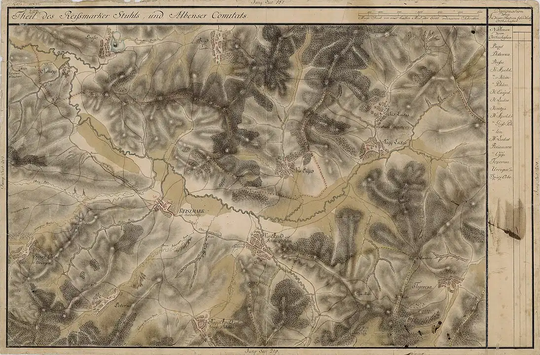
View Larger Map Miercurea Sibiului, formerly Mercurea, Mercurea Sibiului (in the Saxon dialect Reismuert, in German Reussmarkt, Reußmarkt, Reissmarkt, in Hungarian Szerdahely, Szászszerdahely) is a… Read More »Wednesday of Sibiu (map)
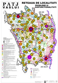
The map monitors mono-industrial areas, areas with migratory potential, the deficiency of social and commercial infrastructure, health risks. The map was drawn up at the request of the Vaslui County Council. Read More »Vaslui County - Map of economic and social dysfunctions
Geographical map of Bihor county The following are illustrated: the main localities, the landforms, the roads
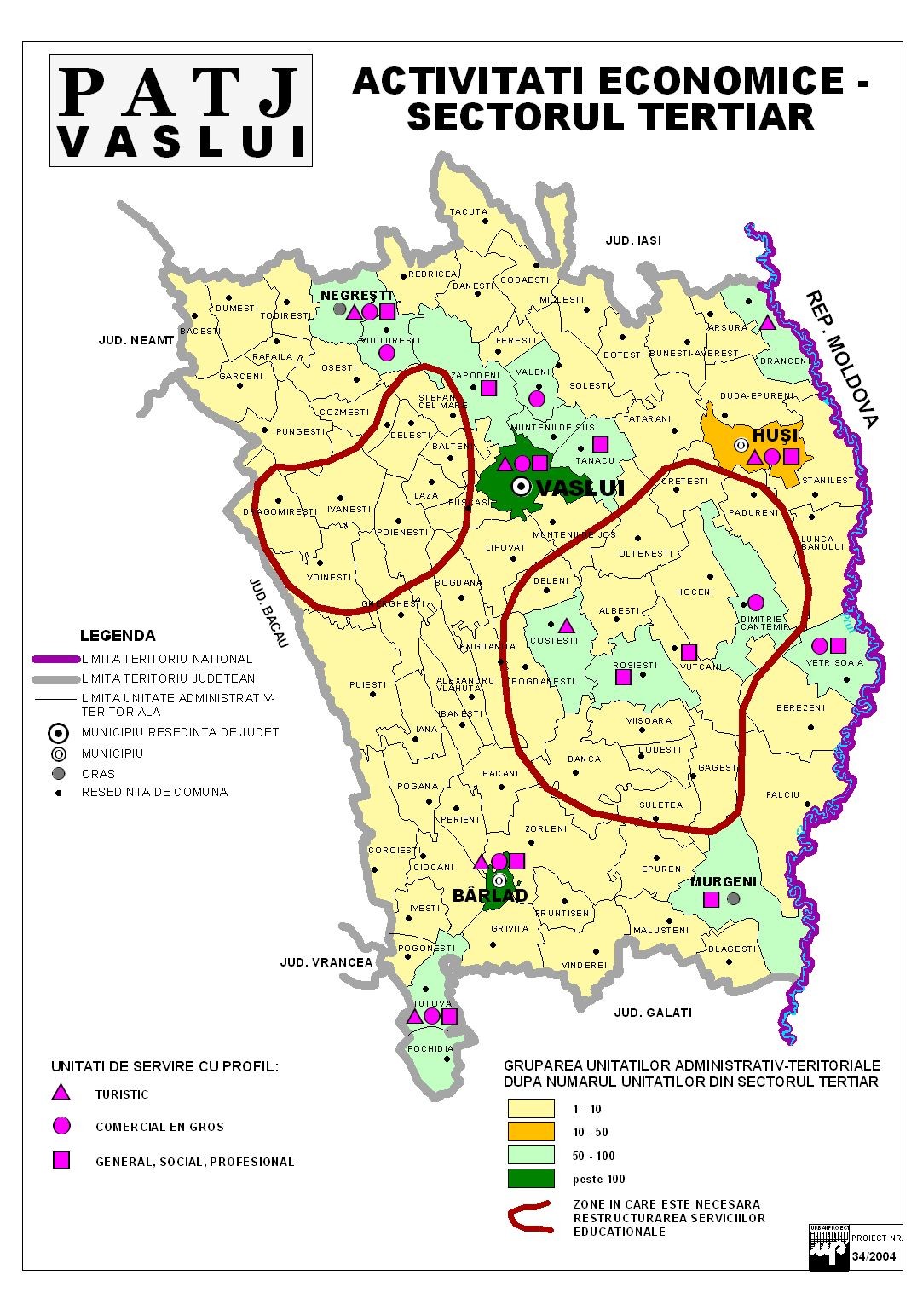
Economic map - tertiary sector - of Vaslui County: wholesale shopping centers, tourism services, other services (social, general, professional) are shown.

The industrial branches, services, agricultural lands, their specificity and quality are illustrated. LINK: Original map (large size)

Tourist routes approved by the Danube Delta Biosphere Reserve for tourism on waterways and for hiking. There are 15 routes available on waterways and 9… Read More »Danube Delta - Tourist map / Danube Delta Travel Map
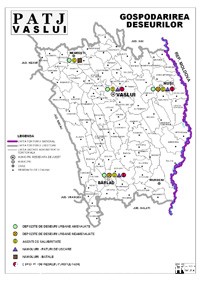
The map mentions organized, unorganized and hazardous waste deposits LINK

The communes, cities and municipalities of Vaslui county in an interactive online map, with the contact details for each town hall, address, area, the name of the mayor and the website, there... Read More »Administrative map of Vaslui county

Transportation in Bacau county: railways, roads, European roads, national roads, county roads
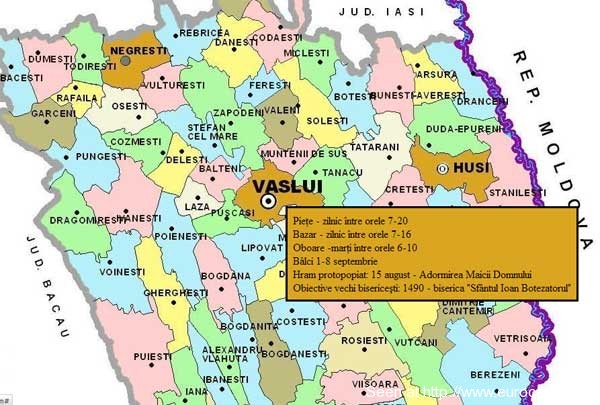
Fairs, markets and festivals in Vaslui County - commercial and tourist map of Vaslui County Click on the map to activate it, then hold the mouse... Read More »Vaslui County - commercial map - fairs, markets, festivals
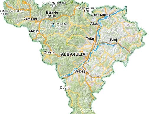
Tourist and administrative map of Alba county, for online use only. They are illustrated: the localities of Alba, fortresses and castles, nature reserves, churches and monasteries, museums... Read More »Alba County - interactive tourist and administrative map
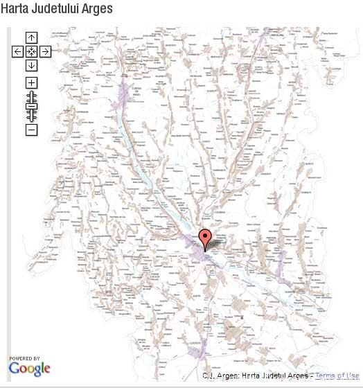
Interactive map of Arges county - exclusively online The relief, the towns of Arges, the roads and county roads, watercourses and lakes are mentioned. Keywords:… Read More »Arges county, interactive map

Online use only. The map includes the cities, municipalities and communes of Valcea County, and each administrative unit opens with a link an informative opus about the locality's town hall,... Read More »Valcea County – Interactive administrative map (Valcea Department, Romania Map)

By accessing the active links on the map, you will have access to general data about the localities in Alba county (cities, communes and villages in the component), administrative data (addresses... Read More »Alba County – Interactive administrative map
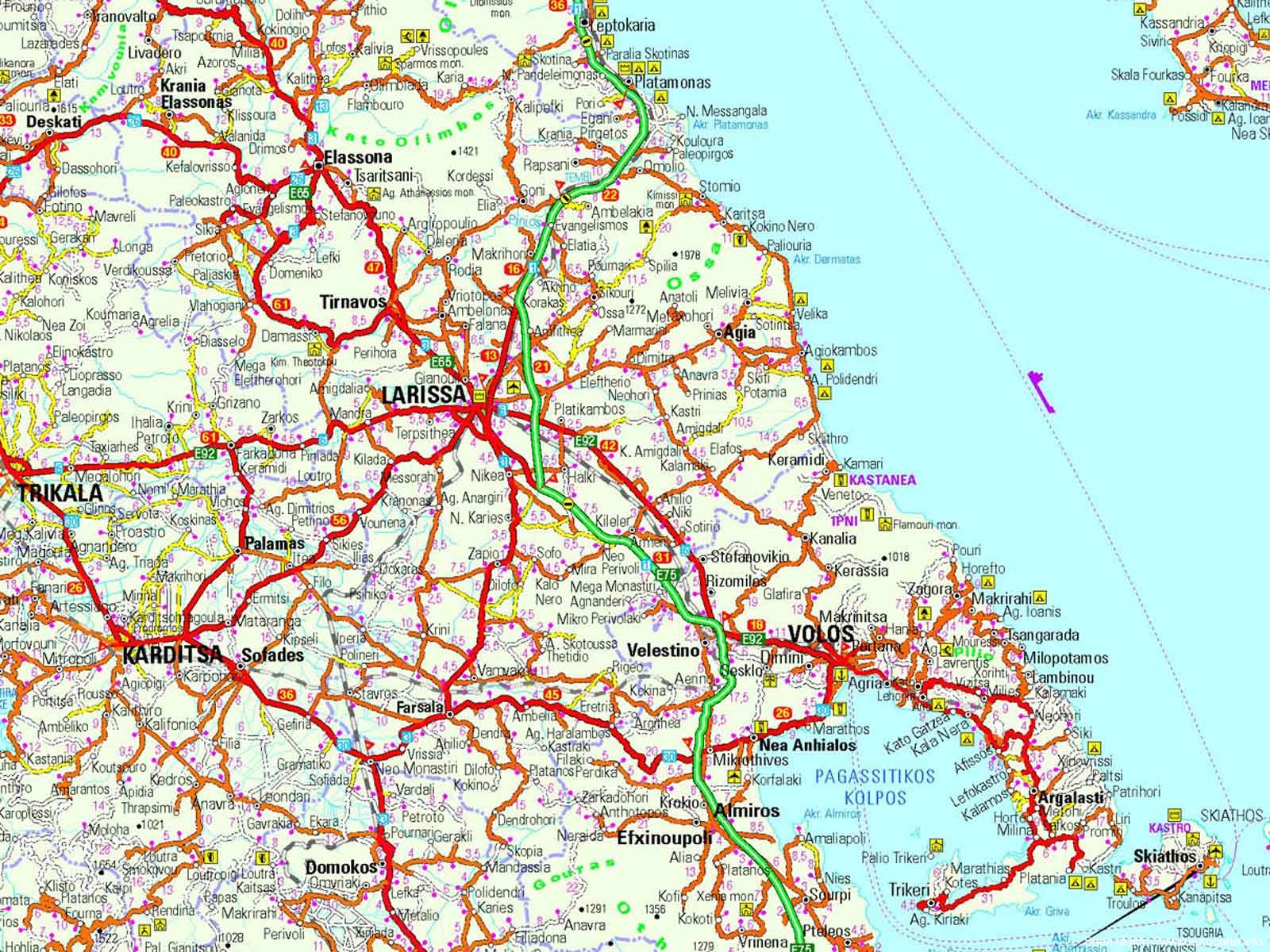
The map is optimized for use on mobile phones (resolution 1600×1200 px). You can download it and use it offline. Tourist map of mainland Greece (Volos region –… Read More »Map: Trikala – Volos – Skiathos – Paralia (Coastal map of Aegean Greece)
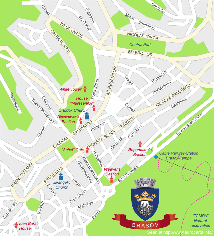
Brasov city map (TRansilvania, Romania) for online and offline use. They appear: the central streets, the historic center, the main tourist attractions of Brasov and Tampa. (The Schei Gate, the Bastions... Read More »Brasov City Map – Brasov city map
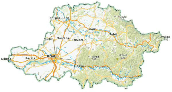
Click on the map to enter the interactive section of the map. It can be used exclusively online. The map includes: the relief of Arad county, the roads and paths... Read More »Arad (Romania) – Online interactive map / Interactive Map

Interactive map of Focsani municipality and Vrancea county, exclusively for online use. Options: Stylized map, relief map, satellite, hybrid map. Localities and roads are shown... Read More »Map of Focsani (Vrancea, Romania) – Yahoo Maps

interactive online map of Alba county, with the county seat - Alba Iulia - all towns in Alba county, national and county roads between towns... Read More »Alba County - interactive map (tourist, relief and road)
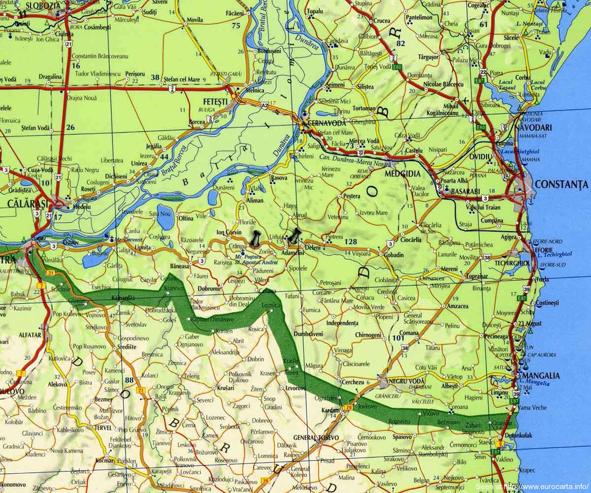
Two important tourist attractions in the south of Dobrogea, the Roman monument at Adamclisi and the holy place Cave of Saint Andrew the Apostle are rarely visited due to the difficult roads... Read More »Map of Adamclisi and Sf. Andrei Cave (Constanta county)

Abrud, located in the mountain region of the Western Carpathians (Western Mountains). See pictures from Abrud and the area. Adjacent towns and roads are shown on the map... Read More »Abrud (Apuseni) Tourist and road map