
EEA countries / EEA States 2020
List of EEA states / EEA States List in 2020: Portugalia/Portugal Spain / Spain France / France Italy / Italy Germany / Germany Ireland / Ireland... Read More »EEA countries / EEA States 2020
List of EEA states / EEA States List in 2020: Portugalia/Portugal Spain / Spain France / France Italy / Italy Germany / Germany Ireland / Ireland... Read More »EEA countries / EEA States 2020

The results of the presidential elections between 1990 and 2019 with the differences recorded between the two rounds. Read the article: Who wins the presidential elections: Bucharest or the diaspora? For the profile… Read More »Electoral maps and analyzes in Cultura magazine

(includes map of European cities and trade in the 7th century)

Map size: 2460×1187 px (pixels) Tourist resort in the vicinity of the old Byzantine city, today in Bulgaria, - Nesebar. Tourist attractions include the beach, water sports and the site… Read More »Sunny Beach (BG) tourist map with hotels
To find out road distances, activate the map below (Get Directions command) LINK Options: Directions, distances, traffic estimation. Get Directions
A Stratfor analysis summarizes the conflicts in the Republic of Moldova, respectively the separatism of the Transnistrian and Gagauz regions. Although both conflicts had only a short violent part, they... Read More »Map of frozen conflicts in the Republic of Moldova
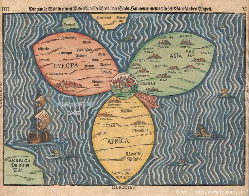
The cloverleaf map of the world, made in 1581 by Henrich Butling (Buntingus, Bunting, Pendingius), with the continents of the old world in the shape of three leaves and... Read More »A planiglob from 1581 – the world as clovers
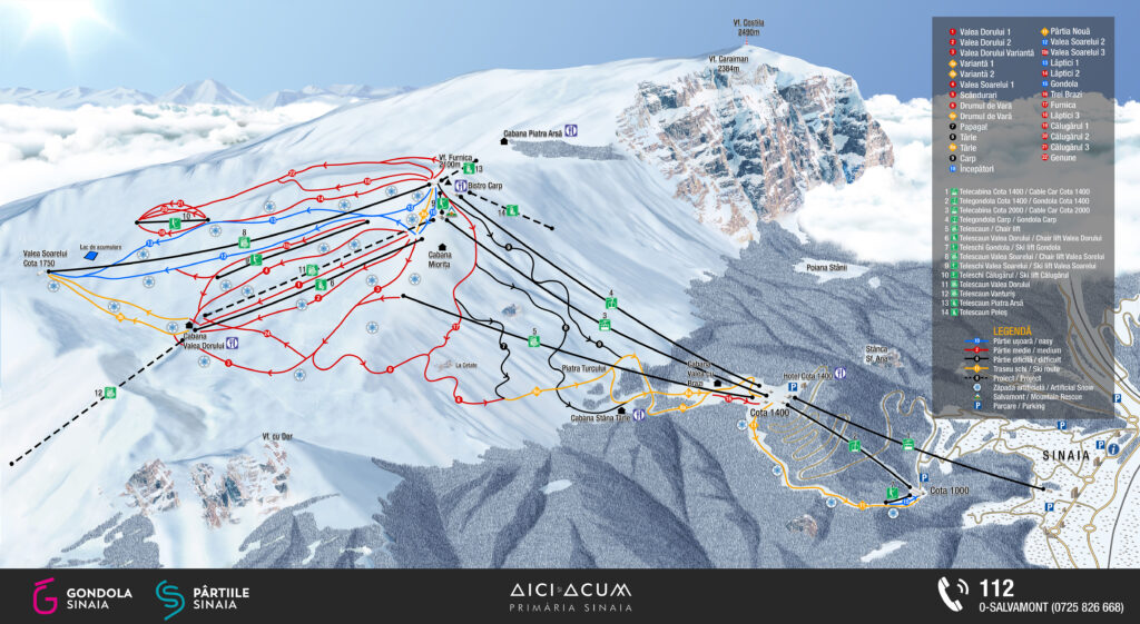
Teleshi Gondola – model: SUNKID COMFORT STAR- SUNKIND BRUCKSCHLOGL AUSTRIA – length: 112 m – maximum speed: 2.5 m/s – transport capacity: … Read More »Ski lift Gondola (in Sinaia resort)
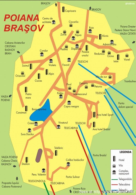
Tourist maps of Poiana Brasov resort, Brasov County, Romania: 1. Map of the resort, with hotels, cabins, guesthouses and other tourist facilities 2. Map of the ski areas... Read More »Poiana Brasov - tourist maps

Click: HERE to open the map in very large dimensions, the map of economic activities and economic development projects in Siubiu County, prepared by PATJ for... Read More »Sibiu County - Updated economic map

Sibiu County Council - Waste water and waste management in the county. The map also highlights the Mures hydrographic basin
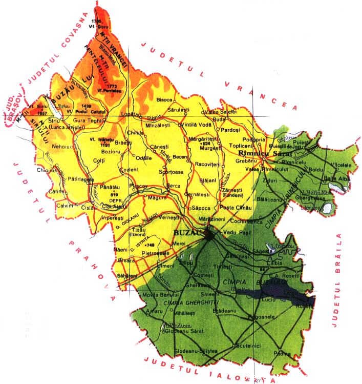
The relief of Buzau County: Baragan Plain, Dealul Mare, Curbura Subcarpathians, Curbura Carpathians, Buzaului Mountains. The Gherghite Plain, the Ramnic Plain, the Cislau Depression, the Penteleu Mountains, the Siriului Mountains,... Read More »Buzau County - geographical and relief map

The wine road, the fruit road and the road of voivodes Landmarks: Ploiesti, Campina, Valenii de Munte, Baicoi, Urlati, Valea Calugareasca, Nisipoasa, Filipestii de Padure

Are mentioned: Hotel Intercontinental, Unirii Place, Universitatii Place, The House of Parliament, The Atheneum, The Royal Palace (The Palace Hall), the Victory Place (The Gouvern... Read More »Tourist Objectives in Bucharest (short map)
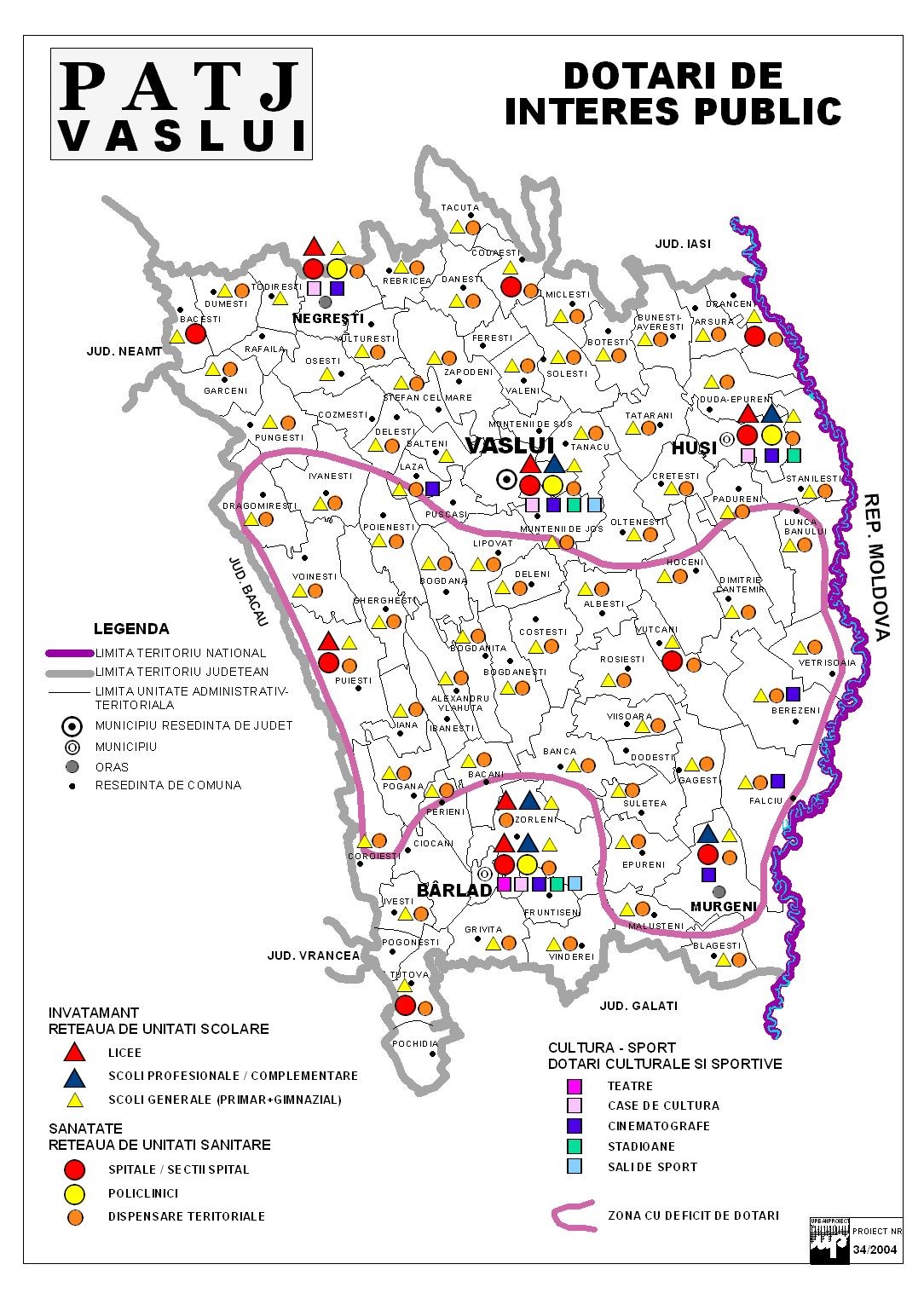
They are represented: schools, hospitals, cultural institutions (theatres, cultural centers, cinemas), gyms and stadiums

RO: Cluj County - map of localities, roads and landforms On the map are mentioned: Cluj Napoca City, Transilvaniei Plain, Gilau Mountains, Mt. Read More »Cluj County Map / Cluj Department Map (in Transylvania)
Online and offline maps from Romania Offline Maps of Romania: / Offline maps of Romania online purchase for wall maps and leaflets Romania –… Read More »Maps from Romania - online+offline

Towns on the Teleajen Valley: TELEAJEN VALLEY Cheia Maneciu Drajna Slanic Valenii de Munte Boldesti Scaieni

Mentions: Sinaia, Campina, Poiana Campina, Telega, Banesti, Brebu, Valea Doftanei, Provita, Breaza, Cornu, Comarnic, Busteni, Azuga PRAHOVEI VALLEY Azuga Busteni Sinaia Comarnic Breaza Campina VALEA... Read More »Tourist map Prahova Valley and Doftanei Valley

Road map of Europe in interactive format / Europe travel Map interactive format View enlarged map SOURCE 1: GOOGLE MAPS (UP) / SOURCE 2: BING... Read More »Road map of Europe / Europe Routier Map
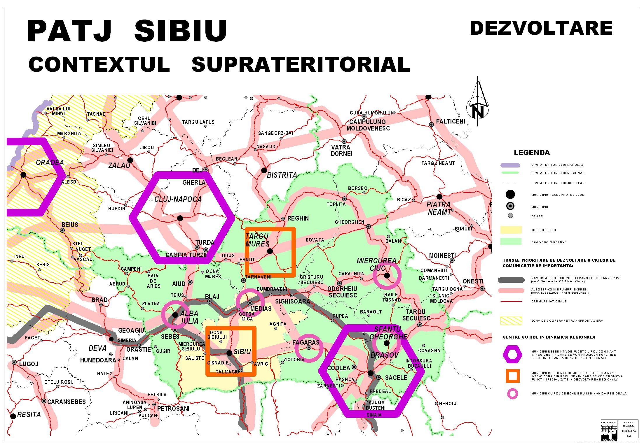
Economy: Transylvania (Romania) macroregional map Cluj Napoca – Sibiu, Oradea, Targu Mures, Brasov, Miercurea Ciuc. Regional relations, infrastructure and the road network

Important objectives on the map: Municipality of Buzau, Municipality of Ramnicu Sarat, Sarata Monteoru, Berca, Arbanasi, Mud volcanoes, Merei, Balta Alba, Cochirleanca, Robeasca, Siriu Dam, Racoviteni, Margaritesti, Gura... Read More »Buzau County Travel Map / Buzau County Travel Map

Detailed (static) map with all the hotels and tourist attractions in the Golden Sands resort, located in Bulgaria, on the Black Sea coast, between Varna and Balchik. Read More »Map of the Golden Sands resort in Bulgaria / The Golden Sands Travel Map

Information about the ski area Highest point of the area: 2,090 m Lowest point of the area: 1,006 m Number of installations of… Read More »Skiing in Sinaia - the Sinaia ski area