
Partia Tarle (from the Sinaia ski area)
8. Târle Black Slope - altitude: departure: 1870 m; arrival: 1649 m – slope length: 534 m – slope width: 59-60 m – served by… Read More »Partia Tarle (from the Sinaia ski area)
8. Târle Black Slope - altitude: departure: 1870 m; arrival: 1649 m – slope length: 534 m – slope width: 59-60 m – served by… Read More »Partia Tarle (from the Sinaia ski area)
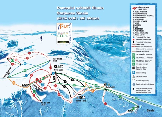
9. Carp Părtie necără - altitude: departure: 2056 m; arrival: 1607 m – slope length: 1382 m – slope width: 50-124 m – served by… Read More »Carp Party (Sinai)
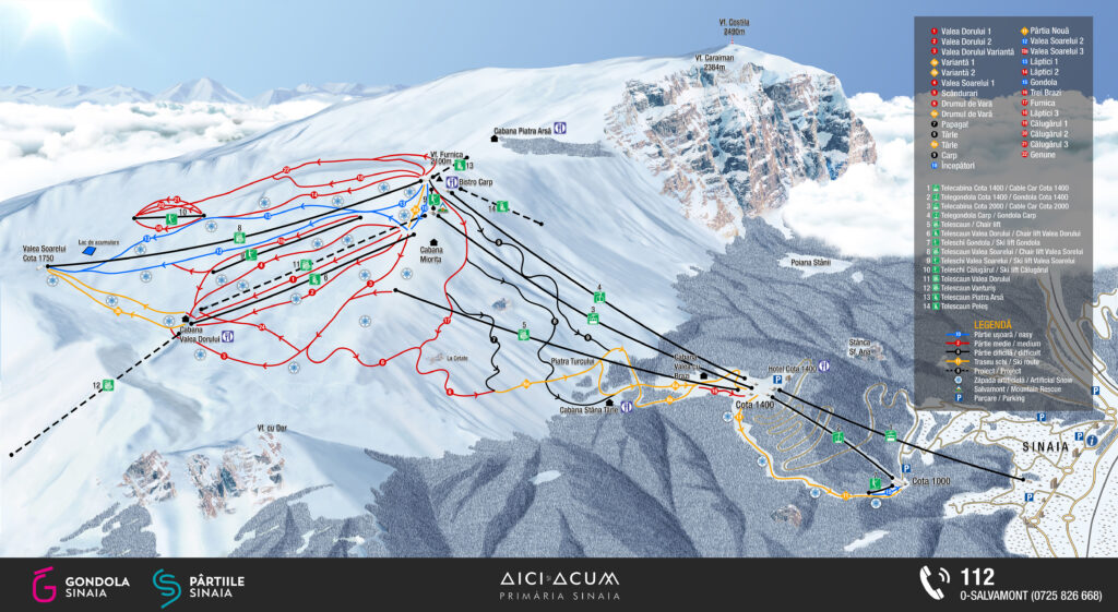
Sinaia Gondola – model: 8MGD – DOPPELMAYR AUSTRIA – length: 1312 m – maximum speed: 6m/s – transport capacity: 1700 people/hour… Read More »The cable car from Sinaia
1. Valea Dorului 1 Red slope – altitude: departure: 2040 m; arrival: 1822 m – slope length: 775 m – slope width: 30-50 m –… Read More »The parts of Valea Dorului in Sinaia

10. Beginners Blue slope - altitude: departure: 2062 m; arrival: 2042 m – slope length: 173 m – slope width: 40-41 m – without facility… Read More »The Beginners Party from Sinaia
Planking Red slope - altitude: departure: 1969 m; arrival: 1821 m – slope length: 506 m – slope width: 59-69 m – served by chairlift and… Read More »Partia Scandurari (from the Sinaia ski area)
7. Parrot Părtie necără - altitude: departure: 2045 m; arrival: 1650 m – slope length: 2972 m – slope width: 20-50 m – served by… Read More »Partia Papagal (Sinaia ski area)
Valea Soarelui 1 Red slope - altitude: departure 2035 m; arrival: 1821 m – slope length: 1191 m – slope width: 28-103 m – served… Read More »The Valley of the Sun from Sinaia

13. Laptici 1 Blue slope – altitude: departure: 2090 m; arrival: 1760 m – slope length: 1900 m – slope width: 40 m – served… Read More »The Lactic slopes of the Sinaia ski area
The Sun chairlift – model: CD4C – LEITNER ITALIA – length: 1618 m – maximum speed: 5m/s – transport capacity: 1800 people/hour –… Read More »The Soarelui chairlift (in the Sinaia resort, ski area)
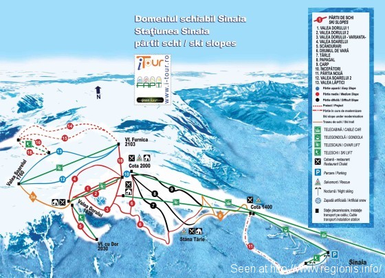
16. Valea cu Brazi Red slope - altitude: departure: 1500 m; arrival: 1385 m – length of the slope: 300 m – width of the slope: 20-25 m –… Read More »Partia Valea cu Brazi from Sinaia

Indicated locations: Ploiesti, Campina, Baicoi, Plopeni, Valenii de Munte, Mizil, Valea Calugareasca, Brazi, Brebu, Breaza, Sinaia, Busteni, Slanic Prahova Recommendations: Local transport on the Prahova Valley... Read More »Map of Prahova county
11. New Slope Red Slope – altitude: departure: 1416 m; arrival: 1026 m – slope length: 1800 m – slope width: 20-46 m – served… Read More »The New Part of the Sinaia Ski Area (artificial)
15. Blue Slope Gondola – altitude: departure: 1026 m; arrival: 1006 m – slope length: 150 m – slope width: 40 m – served by… Read More »Gondola Party from Sinaia

Road and administrative map of Olt County, with national and county roads, railways and the main towns. Objectives shown on the map: Slatina Municipality, Corabia, Caracal,... Read More »Olt County - Road and administrative map

Interactive tourist and road map of the historical monument monasteries in Neamt county. Click on the map to activate it and to see details... Read More »Monasteries from Moldova - map of monasteries from Neamt county

Interactive map of Neamt county, with mention of the main towns, tourist attractions, roads, highways and railways. Click on the image below... Read More »Neamt County – administrative, touristic, road and railway interactive map
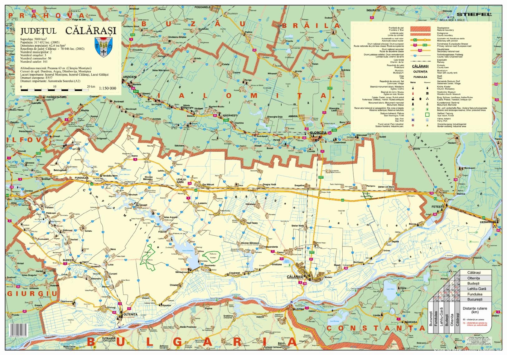
Map of Calarasi county (south of Muntenia, Romania, on the Danube). Localities, the Soarelui highway, national and county roads, as well as irrigation canals and places of... Read More »Calarasi County - administrative, road and railway map

Waters (rivers and lakes in Buzau county) are marked on the map: Buzau river, Ramnicu Sarat river, Sarata, Calmatui, Saratel, Calnau rivers Lakes: Balta Alba, Balta... Read More »Buzau County - hydrographic map

School camps in Buzau county - map. They are located: Monteoru Camp, Poiana Pinului Camp, Arbanasi Camp, Fisici Camp, Hartagu Camp

The website of the Prahova County Council offers a detailed map of the county at http://www.cjph.ro/upload/files/Harta_PH_2007.pdf The map includes localities, landforms, public roads (roads, railways), elements... Read More »Prahova County - detailed map in PDF format

CRICOVULUI VALLEY Mizil Urlati Valea Calugareasca

Administrative map of Buzau County - localities, towns and communes, with territorial boundaries. Localities of reference: Ramnicu Sarat, Magura, Pogoanele, Florica, Glodeanu, Magura, Gura Techii,... Read More »Buzau County - territorial administrative map

for an even larger version of the map click here the map includes demographic, administrative and economic data from Sibiu County. Key points: demographic estimates, network... Read More »Sibiu County - demographic and economic map